- News
- World
Torrential rain has triggered the worst flooding in decades in Indonesia, Sri Lanka, Thailand, Vietnam and Malaysia. Steve Turton unpacks why the region has been savaged by extreme weather
Monday 01 December 2025 10:17 GMTComments CloseAerials show scale of flooding in Indonesia as national disaster try to reach affected areas
For free real time breaking news alerts sent straight to your inbox sign up to our breaking news emails
Sign up to our free breaking news emails
Sign up to our free breaking news emails
Email*SIGN UPI would like to be emailed about offers, events and updates from The Independent. Read our Privacy notice
More than 900 people are dead, thousands more missing and millions affected by a band of cyclones and extreme monsoonal weather across southern Asia. Torrential rain has triggered the worst flooding in decades, accompanied by landslides. Indonesia, Sri Lanka, Thailand, Vietnam and Malaysia have been hit hardest. The death toll is likely to rise significantly.
Normally, cyclones don’t form close to the equator. But Cyclone Senyar formed just north of the equator in the Malacca Strait. It triggered lethal flooding in Sumatra and peninsular Malaysia last week.
It wasn’t alone. Other tropical cyclones formed along a zone of converging trade winds north of the equator. Typhoon Koto caused severe flash floods and landslides in the Philippines before weakening as it neared Vietnam. Tropical Cyclone Ditwah devastated Sri Lanka. One reason Sumatra was hit by such severe flooding was due to the unusual interaction between Typhoon Koto and Cyclone Senyar, which has now weakened.
 open image in galleryAn aerial view shows houses partially submerged in floodwaters after heavy rainfall in Kaduwela on the outskirts of Colombo on November 29, 2025 (AFP via Getty Images)
The near-simultaneous emergence of these intense storms isn’t unheard of, and equatorial cyclones are rare but known. But the devastation is extraordinary. Sri Lankan President Anura Kumara Dissanayake described the floods as the “most challenging natural disaster” in the country’s history. Is there a climate link? We don’t know yet, but we do know climate change is projected to trigger fewer cyclones overall, but with higher intensity.
Why are cyclones rare near the equator?
Cyclones, typhoons and hurricanes are different names for the same strong, spinning tropical storms. These storms form over large expanses of warm water – but not usually on the equatorial seas.
This is because there’s not enough Coriolis force from Earth’s rotation at the equator to spin storms into their classic cyclonic structure.
The closest cyclone to the equator was the 2001 Tropical Storm Vamei which formed at just 1.4°N. Cyclone Senyar formed at 3.8°N.
While tropical cyclones can form in any month, they’re more common between July and October in the northwest Pacific and North Indian oceans. Cyclone Senyar and Typhoon Koto formed in the Northwest Pacific Basin, which has the largest, most frequent and most intense tropical cyclones in the world. Several devastating typhoons have hit the Philippines and parts of southern China this year.
About the author
Steve Turton is an Adjunct Professor of Environmental Geography, at the CQUniversity, Queensland, Australia. This article is republished from The Conversation under a Creative Commons license. Read the original article
One reason these cyclones have caused widespread damage is because they have hit countries where cyclones are rare, such as Indonesia and Malaysia.
Tropical cyclones are often smaller and much less common in the North Indian Ocean, including the Bay of Bengal and Arabian Sea. But Cyclone Ditwar tracked directly down Sri Lanka’s east coast, magnifying the damage.
Is there a climate link?
As the world’s oceans and atmosphere warm at an accelerating rate due to the rise in greenhouse gases from burning fossil fuels, tropical cyclones are expected to become more intense.
This is because cyclones get their energy from warm oceans. The warmer the ocean, the more fuel for the storm.
The warming atmosphere is supercharging the global water cycle, and peak rainfall rates are increasing. When more rain falls in a short time, flash flooding becomes more likely.
We can’t immediately say climate change made these storms worse, as it takes time to pinpoint any link.
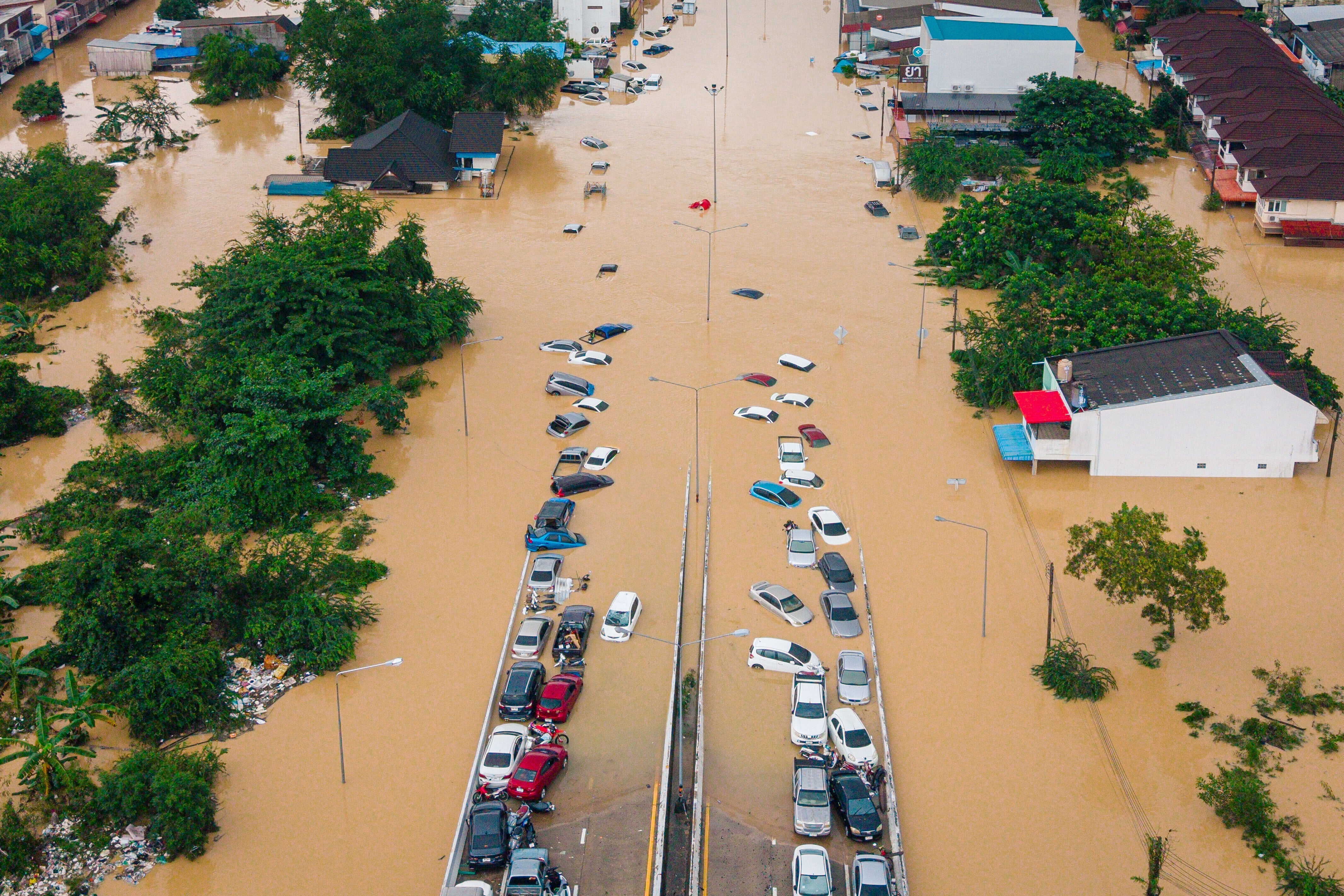 open image in galleryCars and houses are submerged in floodwaters in the Songkhla province of southern Thailand, Nov. 26, 2025 (Copyright 2025 The Associated Press. All rights reserved.)
What does this mean for Australia’s cyclone season?
Many Australians will wonder whether these devastating cyclones across Asia are a warning for northern Australia’s monsoon season.
The wet season has started with a bang in northern Australia, after Severe Tropical Cyclone Fina caused damage and disruption across the Top End and Kimberley last week. It was very early for a cyclone in the south Pacific and Indian oceans, as the season runs November to May.
Last week also saw the most damaging spring storms in more than a decade in southeast Queensland and northern New South Wales. Giant hail and destructive winds did major damage, costing one insurer an estimated A$350 million.
This doesn’t mean a bad cyclone season is guaranteed. It’s not possible to predict individual tropical cyclone events far in advance.
All indicators point to a mixed wet season across the north this year, with below-average rainfall across much of the northwest and average to above-average rainfall across the northeast.
Australia’s Bureau of Meteorology has just declared a La Niña in the Pacific. La Niña typically bring cooler, wetter weather to northern Australia and a stronger monsoon and higher risk of cyclones. This La Niña is likely to be relatively weak and short-lived, which is why rainfall predictions are largely average.
Across most of the Coral Sea, sea surface temperatures are up to 2°C above normal. This unusual warmth increases the risk of cyclone formation as well as more intense monsoonal rains and flooding in coming months.
In the south, there’s increased risk of heatwaves and bushfires, with a very hot summer forecast across most of Australia.
The Bureau of Meteorology recently ended seasonal cyclone forecasts as it’s no longer possible to do so reliably. Until now, meteorologists have used historic data to reasonably accurately model the total number of cyclones in a season. But the climate is now changing so fast it’s no longer possible to do this. As rescue attempts continue in many countries in the region, it’s clear we are now entering uncharted territory.
More about
CyclonesWeatherdeath tollThe ConversationJoin our commenting forum
Join thought-provoking conversations, follow other Independent readers and see their replies
Comments